Total Pageviews

About Me

My photo
Im a pilot at zero four flight school in margate,currently studying for my commercial pilots licence. I really love muscle cars and hope to oneday own a 1967 mustang fastback,its also my dream to get into an international airline as the pilot in command.

16/08/2011

VOR tracking beacons

VORs are assigned radio channels between 108.0 MHz (megahertz) and 117.95 MHz (with 50 kHz spacing); this is in the VHF (very high frequency) range. The first 4 MHz is shared with the ILS band (See Instrument landing system). To leave channels for ILS, in the range 108.0 to 111.95MHz, the 100 kHz digit is always even, so 108.00, 108.05, 108.20, and so on are VOR frequencies but 108.10, 108.15, 108.30, and so on, are reserved for ILS.
The VOR encodes azimuth (direction from the station) as the phase relationship of a reference and a variable signal. The omni-directional signal contains a modulated continuous wave (MCW) 7 wpm Morse code station identifier, and usually contains an amplitude modulated (AM) voice channel. The conventional 30 Hz reference signal is on a 9960 Hz frequency modulated (FM) subcarrier. The variable amplitude modulated (AM) signal is conventionally derived from the lighthouse-like rotation of a directional antenna array 30 times per second. Although older antennas were mechanically rotated, current installations scan electronically to achieve an equivalent result with no moving parts. When the signal is received in the aircraft, the two 30 Hz signals are detected and then compared to determine the phase angle between them. The phase angle by which the AM signal lags the FM subcarrier signal is equal to the direction from the station to the aircraft, in degrees from local magnetic north, and is called the "radial."
This information is then fed to one of four common types of indicators:
  1. An Omni-Bearing Indicator (OBI) is the typical light-airplane VOR indicator[3] and is shown in the accompanying illustration. It consists of a knob to rotate an "Omni Bearing Selector" (OBS), and the OBS scale around the outside of the instrument, used to set the desired course. A "course deviation indicator" (CDI) is centered when the aircraft is on the selected course, or gives left/right steering commands to return to the course. An "ambiguity" (TO-FROM) indicator shows whether following the selected course would take the aircraft to, or away from the station.
  2. A Horizontal Situation Indicator (HSI) is considerably more expensive and complex than a standard VOR indicator, but combines heading information with the navigation display in a much more user-friendly format, approximating a simplified moving map.
  3. A Radio Magnetic Indicator (RMI), developed previous to the HSI, features a course arrow superimposed on a rotating card which shows the aircraft's current heading at the top of the dial. The "tail" of the course arrow points at the current radial from the station, and the "head" of the arrow points at the reciprocal (180 degrees different) course to the station.
  4. An Area Navigation (RNAV) system is an onboard computer, with display, and up-to-date navigation database. At least two VOR stations, or one VOR/DME station is required, for the computer to plot aircraft position on a moving map, or display course deviation relative to a waypoint (virtual VOR station).
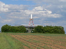
D-VORTAC TGO (TANGO) Germany
In many cases, VOR stations have co-located DME (Distance Measuring Equipment) or military TACAN (TACtical Air Navigation) — the latter includes both the DME distance feature and a separate TACAN azimuth feature that provides military pilots data similar to the civilian VOR. A co-located VOR and TACAN beacon is called a VORTAC. A VOR co-located only with DME is called a VOR-DME. A VOR radial with a DME distance allows a one-station position fix. Both VOR-DMEs and TACANs share the same DME system.
VORTACs and VOR-DMEs use a standardized scheme of VOR frequency to TACAN/DME channel pairing so that a specific VOR frequency is always paired with a specific co-located TACAN or DME channel. On civilian equipment, the VHF frequency is tuned and the appropriate TACAN/DME channel is automatically selected.

Seaweed as jet fuel

For airlines, the solution to soaring fuel prices might be as simple as seaweed.
Virgin Atlantic, Air New Zealand, and Boeing are working together to create the world’s first green aviation fuel made from pond-grown algae.
Higher fuel prices and growing concerns over environmental damage caused by conventional aviation fuel are driving plans to produce biofuels based on algae.
Virgin’s Sir Richard Branson says that the concept has “huge potential,” adding, that it’s a source of energy that “doesn’t lead to deforestation or take away land or water from the cultivation of essential food crops.”
Why algae? Scientists say it can grow incredibly fast – doubling in size in a few hours – and it does not need fresh water or good quality land.
Thick green algae produces at least 15 times more oil per hectare than alternatives such as palm oil, soya or jatropha, a nut-bearing shrub cultivated in several countries as a biofuel.
Separately, Continental Airlines, Boeing, and GE Aviation is hoping to flight test a type of biofuel in 2009. Green Car Congress reported in March that green fuels are ready for takeoff.
The Continental Airlines biofuel flight will use a Boeing Next-Generation 737 equipped with CFM International CFM56-7B engines, using a blend of between 20%-50% of a second-generation biofuel in one engine.
Although they have yet to select the type of biofuel to use, the partners say that it will be a second-generation fuel that does not impact food production. It will also be able to be produced in sufficient quantities to support a pre-flight test schedule that includes laboratory and ground-based jet engine performance testing to ensure compliance with stringent aviation fuel performance and safety requirements.
In February 2008, Virgin Atlantic, Boeing, GE Aviation, and Imperium Renewables successfully flight-tested a Boeing 747 equipped with GE engines using a 20 percent blend of a biojet fuel—a transesterified bio-kerosene — derived from babassu and coconut oil in one engine.
This sounds good. But with fuel prices likely to fall now that Saudi Arabia has decided to increase oil production, will these alternative fuel initiatives endure?
Only time will tell.

Two missing planes

Five helicopters, including an SA Air Force Oryx, which was dispatched from the Hoedspruit Airforce Base, lifted off at about 40 minute intervals throughout the afternoon, searching in vain in mountainous terrain.
By 5pm yesterday, the search was called off.
"They are currently rerouting the helicopters to the centre and there has been no indication of a crash site yet,"Greater Mopani District Municipality spokesperson Mashadi Mathosa said.
At about 4.30pm, the Oryx left with a team of four search and rescue members on board, taking another stab at finding the two Albatros aeroplanes.
On its return, rescue team members, of whom many had to sleep in the veld overnight on Sunday, were fed dinner and coffee.
They were debriefed and had the night to rest, before regrouping to start the search at 6.30am.
Yesterday's search and rescue efforts continued in an atmosphere of tense efficiency, as every bit of information coming in to the centre was plotted on a map, and coordinates of any possible sighting sent to a helicopter.
The helicopter then swooped down to pick up a team of four rescuers, and headed out to the search areas, where the teams were dropped to search on foot.
The search included more than 100 members from various organisations such as the Limpopo Emergency Services, the SAAF, police, the Off Road Rescue and Mountain Rescue units and private pilots. It stretched over an area of between 180km² and 210km² in mountainous and vegetated terrain between Maake and George's Valley in the Wolkberge.
Low cloud cover and heavy fog limited visibility to about 10m, and caused the helicopters to be ineffective as search platforms, and could only be used to ferry search teams.
Aviation authorities lost contact with the two Albatros aircraft, confirmed to be carrying 13 passengers, at around 3pm on Sunday.
The planes were returning to Rand Airport from an airshow organised at the Tarentaal airstrip, about 15km outside Tzaneen.